 Virtual
Chicago
In
an age of Mapquest.com and global positioning systems, maps
have gone totally 21st century. And prehistoric maps are riding
that wave. The University's Paleographic Atlas Project harnesses
some of this new technology to simulate geographical and climactic
changes as well as model fossil and mineral distribution. The
project's Web site contains dozens of maps, slide shows, and
QuickTime movies.

Founded
in 1975 with seed money from Shell Development Corporation,
the project originally studied the Paleozoic era (more than
500 million years ago) and the arrangement of continents in
the pre-Pangaean world. Since then, the project has added other
paleographic eras. Rather than limit the project to the study
of plate tectonics, project scientists-many in the geophysical-sciences
department-have also added other topics, including sea-floor
spreading, paleomagnetism (or the leftover magnetism of prehistoric
rocks), topography, climate, oceanography, and phyto- geography
(the study of plants and their distribution on the planet).
Much
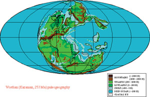
of this information is displayed using maps. The collection
for the Permian period (almost 300 million years ago), for example,
includes a topographical map showing the beginnings of mountain
ranges, such as the Appalachians, and remnants of ranges from
earlier eras. Another map shows the Permian distribution of
minerals, including coals and oil source rocks, and one shows
climate across the continents.
The
Web site also offers illustrations of Permian-era flora, including
Lepidodendron, a treelike plant, and a marattialean tree
fern. A Jurassic-era slide show features photographs of fossilized
ferns and conifers. Visit the site for a glimpse of what was
in your backyard over 500 million years ago.
-Q.J.
World
Wide Web location:
http://pgap.uchicago.edu/

![]()
 Virtual
Chicago