 The University of Chicago Magazine December 1995
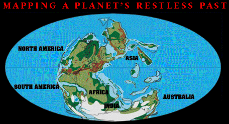
From a handful of specimens that ring the room's broad map table, Alfred Ziegler hefts a smooth, fist-sized, gray rock and points to the rows of scratches on its flattened bottom. A glacier etched the lines, he explains, as it pushed the rock along--hardly a surprising lesson almost a stone's throw from another glacial artifact, Lake Michigan.
But this rock, much older than the lake, came from Australia. The land of the world's largest coral reef once dwelled so far Down Under that its climate was practically polar. "Australia," notes Ziegler, a U of C professor of geophysical sciences, "has had a history of northward motion." The rock he's holding dates to 280 million years ago--before India slammed into Asia, before Africa broke from South America.
It takes a new outlook on time to picture continents as actors, not scenery, on the global stage. That mind-set helps a lot in understanding Chicago's Paleogeographic Atlas Project, an effort Ziegler began in 1975 to chart Earth's changing face, from more than 500 million years ago to the present. From the project's perspective, today's maps are only still frames from an ongoing movie where continents wander the globe, collide, and splinter, and oceans open and close, accordion-like, in the shifting spaces between.
But the ancient footage is buried, fossilized, eroded away, and scattered across a planet. Historians of the world, the Chicago researchers reconstruct past scenes or "paleomaps" from their ever-expanding library of geologic databases. The maps serve needs historical and contemporary: a basis for deducing the paleoclimate and improving forecasts of future climate change, a key to unraveling geography's effect on evolution, a tool for locating potential oil and mineral deposits, and a window onto geologic processes too slow to be understood by charting yesterday's earthquake or last year's tiny shuffle of a continental plate.
Other paleogeographers can fill some of these needs, yet only the Chicago group, says Ziegler, is addressing all of them on a global scale. It's no surprise, then, that its maps, each a painstaking synthesis of the latest scientific clues, are in demand. A series detailing a specific time period can take up to a year to create, and requests have led to a backlog of orders.
Working from their second-floor offices in the Henry Hinds Laboratory for the Geophysical Sciences, the project's members--Ziegler; associate professor David Rowley; graduate students Michael Hulver, SM'85, Paul Markwick, and Feng Xue; research technologist Julia Trice, AB'94; and undergraduate Derek Parker--start with topography: locating continents, coastlines, seaways, and mountain ranges. That's "just the starting point," says Ziegler, for recreating the paleoenvironment, also a project goal. Overlaid on the base map are clues to ancient climates--such as the distribution of coal, which forms under wet conditions, and glacial debris, like the rock from Australia.
Fossils add another layer of information, as Paul Markwick recently showed. In the course of mapping the diversity and geographic range of crocodile fossils, Markwick documented that the animals suffered little decline at the time that dinosaurs went extinct, 65 million years ago. Given crocodiles' own need for mild temperatures, he concluded that a long-term global cooling was unlikely to have played a role in the dinosaurs' death--a finding that helps rule out some of the hypothesized scenarios for the famous mass extinction.
The range of a fossil species can help to pin down a continent's earlier location, but geologists' mainstay for that job is the Earth's magnetic field. Magnetic elements in sedimentary deposits align with a powerful field that girdles the planet; like frozen compasses, they record a continent's orientation and latitude at the time the deposits form. On the ocean floor, the same field leaves its imprint on cooling magma that flows out of mid-ocean ridges--indirectly recording the age of each new strip of seafloor, which in turn reveals the motion of the bordering continents.
Paleomagnetism isn't new. In the 1950s and '60s, its proof of continental drift and seafloor spreading was what sold geologists on plate tectonics--a theory that explains processes from mountain building to earthquake faults through continental "plates" that float, like a fragmented outer shell, atop the denser rock of the Earth's mantle. As paleomagnetic measurement improves, Ziegler notes, more accurate and plentiful data have "moved" some continents by as much as 5 degrees latitude or longitude, compared to maps made just six years ago.
Advances have especially changed paleomaps of China, a project focus since the early 1980s and a puzzling crazy-quilt from the view of plate tectonics. While a single plate has composed most of North America for the past 280 million years, "China in that same interval," says Rowley, "is made of more than a half-dozen pieces that have very independent motion histories."
Together, he and Ziegler have made 15 trips to China; their fieldwork and collaborations with Chinese scientists have helped to map how the fragments of south Asia slowly assembled. The work has netted other gains. Oil companies have helped fund the atlas project from the start because a knowledge of paleoenvironments can suggest where today's deposits of minerals and petroleum lie. When China began taking onshore bids for exploration a few years ago, says Ziegler, "a lot of companies that had no knowledge of Chinese geology all of a sudden were desperate to have information."
And China, says Rowley, is a rock hound's dream: a landscape of conditions so extreme, and rocks so well exposed, that quandaries "related to all geology" can be studied with relative ease. Rowley, for example, is looking at the lofty source of Asia's monsoonal climate: the massive Tibetan plateau raised by India's collision with China. "At what point in the development of the plateau do the monsoons start--what's the critical boundary condition?" The problem can't be solved theoretically, he says. "We want to know the actual relationship in the geological record: How did Tibet grow?"
From Asia to the world, the mapmaking hasn't been quick, Rowley admits, "but the world's a big place." Having spent most of the past 15 years charting the Cenozoic and Mesozoic eras--from the present back roughly 245 million years--Ziegler and Rowley hope soon to redo the project's original maps of the Paleozoic, the era that began 550 million years ago. "There's so much ignorance embedded in those maps," Rowley says, almost wistfully. "And it's not a fault." Like the continents, science doesn't stand still. Mapmaking "isn't capturing a fixed object," he says. "It's capturing an evolving process."
VIEW THE MAPS