 The University of Chicago Magazine December 1995
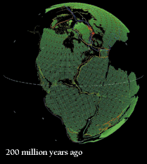
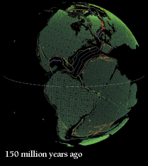
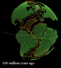
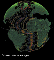
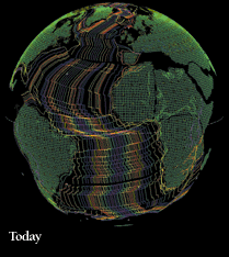
A Global Jigsaw. The spreading Atlantic seafloor tracks the continents' movements, as shown by computer software developed by the Paleogeographic Atlas Project. The colored lines mark strips of ocean crust of a single age, as determined by geomagnetic data. New crust forms at the Atlantic's midocean ridge, then moves outward to either shore. To chart a continent's motion, Chicago's David Rowley works backward in time, progressively "deleting" new crust from the computer image to find the continent's prior location. Seafloor data is one of several tools for the job-what Rowley calls "fitting together pieces of a puzzle in which the shapes of the puzzle change with time." Continental plates change shape, and coastlines even more so, as ocean levels rise and fall and inland seaways advance and retreat. For clarity, today's coastlines are shown below: Pangea begins largely intact, then splits along north-south lines as the Atlantic Ocean begins to open. The southern continents and India separate next, as Africa swings up to form the Mediterranean-to disappear some distant day, geologists predict, as Africa marches north.
VIEW THE MAPS
RETURN TO OPENING OF "MAPPING A PLANET'S RESTLESS PAST"